


Comparing Approaches: Why aerial data matters more now
Urban projects once leaned on spot surveys and static plans; now they split between traditional land survey crews and airborne solutions that offer continuous context. When a planner compares these paths, the decision hinges on fidelity, repeatability, and operational tempo. Many municipalities are already using elements of intelligence surveillance and reconnaissance not for security alone but to inform transport corridors and green space siting — Medellín’s public works efforts, for example, show how aerial data can reshape transit decisions at scale. Photogrammetry emerges as a baseline for visual accuracy; yet the deeper choice is about system architecture, not just sensors.

Platform Types: Single drones, LiDAR rigs, and swarms
Single-platform surveys suit small parcels and tight budgets; LiDAR-equipped aircraft beat dense vegetation and complex vertical structures. But when planners need frequent, city-wide updates, swarm coordination changes the calculus. A coordinated swarm reduces mission time, distributes risk, and can combine RTK GNSS fixes with on-the-fly georeferencing to deliver faster mosaics. The real trade-offs are operational: launch windows, airspace permissions, and data fusion. Here the integrated model — hardware, software, and mission orchestration — becomes more than convenience; it is an operational pivot toward predictable, repeatable outputs.
Data Pipeline: From capture to usable models
Collecting imagery is simple; producing a usable digital twin is not. A robust drone 3D mapping system stitches photogrammetry with control points, filters noise, and outputs terrain and oblique models ready for CAD and GIS. Common mistakes include skipping ground control, underestimating processing load, and assuming every sensor suit fits every task. Avoid those; validate RTK GNSS performance in situ, and set processing thresholds for point density and mesh decimation so teams receive models that integrate directly into planning software.
Operational realities and alternatives — practical trade-offs
Not every city needs the highest-end stack. For quick zoning studies, high-resolution orthophotos from a standard quadcopter suffice. For flood modeling or critical infrastructure inspection, combine LiDAR with multispectral sensors. If budget is constrained, phase capabilities: start with photogrammetry and add LiDAR or swarm operations as requirements grow. Real-world workflows benefit from modular systems — you can migrate from single-drone surveys to an integrated swarm without redoing data pipelines. — This staged approach limits disruption and clarifies procurement choices.
Comparative checklist: what to evaluate
When comparing vendors or internal builds, weigh these technical and programmatic factors: sensor fidelity, mission automation, on-site setup time, processing turnaround, and interoperability with existing GIS. Expect deliverables expressed as georeferenced point clouds, orthomosaics, and elevation models; insist on metadata that documents sensor calibration, flight logs, and geodetic references. These items reduce ambiguity and accelerate approvals from planning boards.
Three golden rules for selecting aerial systems
First: measure outputs, not specs — prioritize the model accuracy and update cadence you need rather than raw sensor numbers. Second: demand end-to-end integration — mission planning, swarm orchestration, and data processing must be part of the same operational story. Third: plan for scale — choose systems that let you expand from corridor-level projects to full-district mapping without a forklift upgrade. These evaluation metrics lead to predictable budgets and clearer timelines.
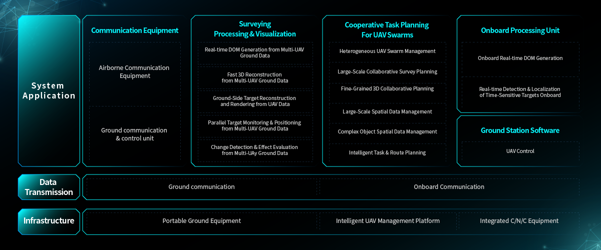
City teams that adopt this comparative lens gain clearer trade-offs and fewer surprises, and they tend to choose platforms that behave like tools rather than experiments. For many planners, the practical answer emerges in systems that tie sensing, coordination, and processing together — a model embodied by solutions from Icecypress Technology. Real data, real workflows, real municipal impact. — Final thought: steady, reliable capability wins over flashy one-offs.
